Sabtu, 28 Mei 2011
jalak bali
Dari Wikipedia bahasa Indonesia, ensiklopedia bebas
| ?Jalak Bali | ||||||||||||||
|---|---|---|---|---|---|---|---|---|---|---|---|---|---|---|
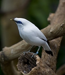
 Jalak Bali di Kebun Binatang Brookfield | ||||||||||||||
| Status konservasi | ||||||||||||||
| Klasifikasi ilmiah | ||||||||||||||
| ||||||||||||||
| Nama binomial | ||||||||||||||
| Leucopsar rothschildi Stresemann, 1912 |
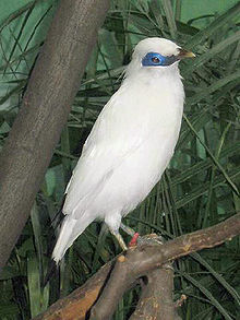
Endemik Indonesia, Jalak Bali hanya ditemukan di hutan bagian barat Pulau Bali. Burung ini juga merupakan satu-satunya spesies endemik Bali dan pada tahun 1991 dinobatkan sebagai lambang fauna Provinsi Bali. Keberadaan hewan endemik ini dilindungi undang-undang.
Jalak Bali ditemukan pertama kali pada tahun 1910. Nama ilmiah Jalak Bali dinamakan menurut pakar hewan berkebangsaan Inggris, Walter Rothschild, sebagai orang pertama yang mendeskripsikan spesies ini ke dunia pengetahuan pada tahun 1912.
Karena penampilannya yang indah dan elok, jalak Bali menjadi salah satu burung yang paling diminati oleh para kolektor dan pemelihara burung. Penangkapan liar, hilangnya habitat hutan, serta daerah burung ini ditemukan sangat terbatas menyebabkan populasi burung ini cepat menyusut dan terancam punah dalam waktu singkat. Untuk mencegah hal ini sampai terjadi, sebagian besar kebun binatang di seluruh dunia menjalankan program penangkaran jalak Bali.
Jalak Bali dinilai statusnya sebagai kritis di dalam IUCN Red List serta didaftarkan dalam CITES Appendix I.
[sunting] Lihat pula
[sunting] Referensi
[sunting] Pranala luar
| Wikimedia Commons memiliki galeri mengenai: |
- (Inggris) BirdLife Species Factsheet
- (Inggris) IUCN Red List
- (Inggris) Red Data Book
| Wikispecies mempunyai informasi mengenai |
Diperoleh dari "http://id.wikipedia.org/wiki/Jalak_Bali"
andes
From Wikipedia, the free encyclopedia
Jump to: navigation, search
This article is about the mountain range in South America. For other uses, see Andes (disambiguation).
| Andes (Quechua: Anti(s/kuna)) | |
| Range | |
| Countries | Argentina, Bolivia, Chile, Colombia, Ecuador, Peru, Venezuela |
|---|---|
| Cities | Bogotá, Santiago, Medellín, La Paz, Cali, Quito, Pasto, Bucaramanga, Arequipa, Mendoza, Cuenca, Cochabamba, Pereira, Ibagué, Salta, Manizales |
| Highest point | Mt. Aconcagua |
| - location | Las Heras Department, Mendoza, Argentina |
| - elevation | 6,962 m (22,841 ft) |
| - coordinates |  32°39′10″S 70°0′40″W / 32.65278°S 70.01111°W / -32.65278; -70.01111 32°39′10″S 70°0′40″W / 32.65278°S 70.01111°W / -32.65278; -70.01111 |
| Length | 7,000 km (4,350 mi) |
| Width | 500 km (311 mi) |
Along its length, the Andes is split into several ranges, which are separated by intermediate depressions. The Andes is the location of several high plateaux – some of which host major cities such as Quito, Bogotá, Arequipa, Medellín, Sucre, and La Paz.
The so-called Altiplano plateau is the world's second-highest plateau following the Tibetan plateau. The Andes extends to seven countries, in alphabetical order: Argentina, Bolivia, Chile, Colombia, Ecuador, Peru, and Venezuela, some of which are known as the Andean States.
The Andes range is the world's highest mountain range outside of the continent of Asia. The highest peak, Mt. Aconcagua, rises to an elevation of about 6,962 m (22,841 ft) above sea level. The peak of Mt. Chimborazo in the Ecuadorean Andes is located at the point on the surface of the Earth that is the most distant one from its centre. This is because of the Earth's equatorial bulge that results from its rotation. The world's highest volcanos are in the Andes, including Ojos del Salado on the Chile-Argentina frontier which rises to 6,893 m (22,615 ft), and over 50 other volcanos that rise above 6,000 m.
Contents[hide] |
[edit] Name
The etymology of the word Andes has been debated. The major consensus is that it derives from the Quechua word anti, which means "high crest". Others believe that Andes comes from Anti Suyu, one of the four regions of the Inca empire. It is more likely however that the word Antisuyo derives from the use of Anti to designate mountain chains. Derivation from the Spanish andén (in the sense of cultivation terrace) has also been proposed, yet considered very unlikely.[edit] Geography
The Andes can be divided into three sections:I. The Southern Andes in Argentina and Chile;
II. The Central Andes, including the Chilean and Peruvian cordilleras and parts of Bolivia;
III. The Northern Andes in Venezuela, Colombia, and Ecuador that consists of two parallel ranges, the Cordillera Occidental and the Cordillera Oriental. In Colombia, north its the border with Ecuador, the Andes split in three parallel ranges, the western, central, and eastern ranges. (The cordillera occidental, central, and oriental).
In the northern part of the Andes, the isolated Sierra Nevada de Santa Marta range is often considered to be part of the Andes. The eastern range of Colombia is the only one that extends to Venezuela.[1] The term cordillera comes from the Spanish word meaning "cuerda", meaning "rope". The Andes range is about 200 km (124 mi) wide throughout its length, except in the Bolivian flexure where it is about 640 kilometres (398 mi) wide. The islands of the Dutch Caribbean Aruba, Bonaire, and Curaçao, which lie in the Caribbean Sea off the coast of Venezuela, were thought to represent the submerged peaks of the extreme northern edge of the Andes range, but ongoing geological studies indicate that such a simplification does not do justice to the complex tectonic boundary between the South-American and Caribbean plates. [2]
[edit] Geology
| Geology of the Andes |
|---|
| Orogenies |
| Pampean orogeny |
| Famatinian orogeny |
| Gondwanide orogeny |
| Andean orogeny |
| Fold-thrust belts |
| Central Andean | Patagonian |
| Batholiths |
| Peruvian Coastal | North Patagonian | South Patagonian |
| Subducted structures |
| Antarctic Plate | Carnegie Ridge | Chile Rise | Farallon Plate (formerly) | Juan Fernández Ridge | Nazca Plate | Nazca Ridge |
| Faults |
| Gastre | Liquiñe-Ofqui | Magallanes-Fagnano |
| Andean Volcanic Belt |
| Northern Zone| Peruvian flat-slab | Central Zone | Pampean flat-slab | Southern Zone | Patagonian Gap | Austral Zone |
| Paleogeographic terminology |
| Arequipa-Antofalla Terrane | Chilenia | Chiloé Block | Cuyania | Iapetus Ocean | Madre de Dios Terrane | Mejillonia | Pampia |
| |
| This section requires expansion. |
[edit] Orogeny
The western rim of the South American Plate has been the place of several pre-Andean orogenies since at least the of the late Proterozoic and early Paleozoic when several terranes and microcontinents collided and amalgamated with the ancient cratons of eastern South America, by then the South American part of Gondwana.The formation of the modern Andes began with the events of the Triassic when Pangea begun to break up and several rifts developed. It continued through the Jurassic Period. It was during the Cretaceous Period that the Andes began to take its present form, by the uplifting, faulting and folding of sedimentary and metamorphic rocks of the ancient cratons to the east. The rise of the Andes has not been constant and different regions have had different degrees of tectonic stress, uplift, and erosion.
Tectonic forces above the subduction zone along the entire west coast of South America where the Nazca Plate and a part of the Antarctic Plate are sliding beneath the South American Plate continue to produce an ongoing orogenic event resulting in minor to major earthquakes and volcanic eruptions to this day. In the extreme south a major transform fault separates Tierra del Fuego from the small Scotia Plate. Across the 1,000 km (620 mi) wide Drake Passage lie the mountains of the Antarctic Peninsula south of the Scotia Plate which appear to be a continuation of the Andes chain.[citation needed]
[edit] Volcanism
Main article: Andean Volcanic Belt
Selasa, 24 Mei 2011
potal geography
From Wikipedia, the free encyclopedia
Wikipedia portals: Culture · Geography · Health · History · Mathematics · Natural sciences · People · Philosophy · Religion · Society · Technology
The Geography Portal
Geography is the study of the location, extent, distribution, frequency and interaction of all significant elements of the human and physical environment on or near the Earth's surface, particularly its features and of the distribution of life on the earth, including human life and the effects of human activity. The word geography derives from the Greek γη (ge) or γαια (gaia) ("Earth") and γραφειν (graphein) ("to inscribe"). Physical geography focuses on the physical, meteorological and ecological patterns and processes on Earth. Human geography focuses on economic, political and cultural processes and features in their spatial dimensions. In addition to studying human and natural features of Earth, Geographers also study Earth's place in the Solar System and the Universe and how this affects the Earth features (e.g. climate, sea currents and tides), as well as physical processes on other planets.
Subportals
Selected article
Trafford Park is an area of the Metropolitan Borough of Trafford, in Greater Manchester, England. Located opposite Salford Quays, on the southern side of the Manchester Ship Canal, it is 3.4 miles (5.5 km) west-southwest of Manchester city centre, and 1.3 miles (2.1 km) north of Stretford. Until the late 19th century it was the ancestral home of the Trafford family, who sold it to financier Ernest Terah Hooley in 1896. Occupying an area of 4.7 square miles (12 km2), it was the first planned industrial estate in the world, and remains the largest in Europe. Trafford Park is almost entirely surrounded by water; the Bridgewater Canal forms its southeastern and southwestern boundaries, and the Manchester Ship Canal, which opened in 1894, its northeastern and northwestern boundaries. Hooley's plan was to develop the Ship Canal frontage, but the canal was slow to generate the predicted volume of traffic, therefore in the early days the park was largely used for leisure activities such as golf, polo, and boating. British Westinghouse was the first major company to move in, and by 1903 it was employing about half of the 12,000 workers then employed in the park, becoming one of the most important engineering facilities in Britain.
Selected picture
| Antelope Canyon, a slot canyon located near Page, Arizona. Image credit: Luca Galuzzi |
Did you know...
- ... that the Upper Harz Water Regale (pictured), a network of dams, lakes, ditches, and tunnels built between 1536 and 1866 to supply water to the mines of the Harz mountains in Germany, is the largest of its kind in Europe?
- ... that the 1770 Port-au-Prince earthquake destroyed all the buildings of Port-au-Prince, in the French colony of Saint-Domingue (the future Haiti)?
- ... that the 2004 Indian Ocean earthquake and tsunami contaminated drinking water in wells along the east coast of Sri Lanka for one-and-a-half years after the event, according to the International Water Management Institute?
- ... that the early-February 1995 winter storm was the only major nor'easter of the 1994–1995 winter?
- ... that nearly all the trees and mangroves of La Ventanilla, Oaxaca, Mexico, were destroyed by Hurricanes Pauline and Rick in 1997?
Categories
Articles
| Antarctica | Afro-Eurasia | Americas |
| Australia | Africa | Eurasia |
| North America | Oceania | Europe |
| Asia | South America | Supercontinents: Gondwana • Laurasia • Pangaea • Rodinia |
WikiProjects
Associated Wikimedia
| Geography on Wikinews News | Geography on Wikiquote Quotes | Geography on Commons Images | Geography on Wikisource Texts | Geography on Wikibooks Textbooks |
Langganan:
Postingan (Atom)


